Blog

The blog of Calgary based photographer J. Dirom.

Sheep River Falls - Cycling in Kananaskis Country

Photo: Dwayne Reilander

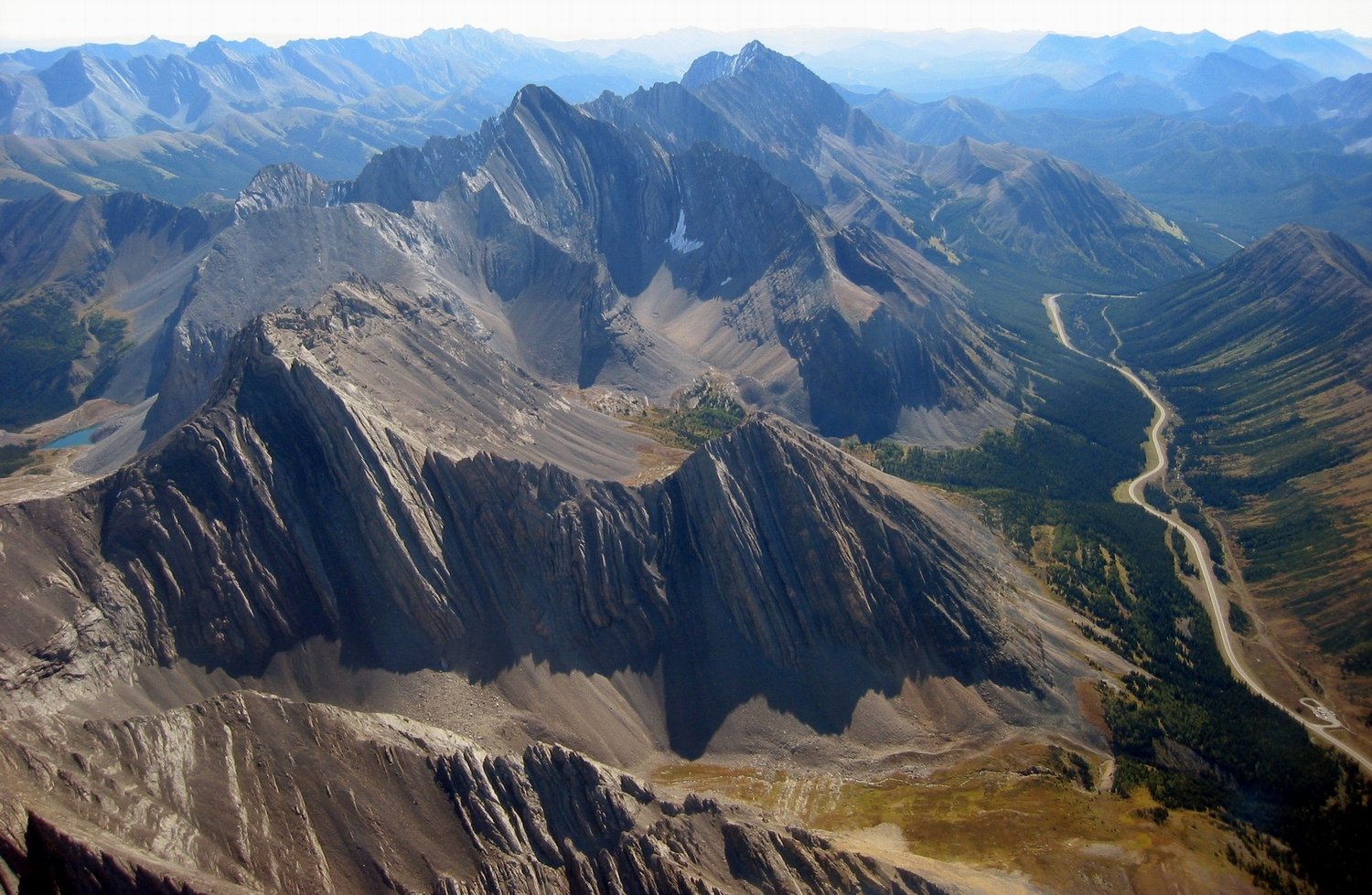
Kananaskis without a doubt has some of the most beautiful beautiful mountain scenery that Alberta has to offer. With seasonal road closures on certain routes, it provides cyclists the opportunity to ride some amazing routes, without having to deal with highway traffic. In this case Sheep River Falls is a great ride that can be enjoyed without the interference of cars before May 15th. This provides the opportunity to experience everything from Bighorn Sheep, deer, the odd bear, and the a beautiful set of falls.

Being Alberta, just be aware and prepared, as people often joke about snowstorms in May (May Long weekend in particular), so it is possible you can get snow even after the road opens. Also note that in areas of this ride, you are likely to be out of cell phone coverage, so be prepared in terms of riding gear, just in case the weather turns, you aren’t out there without a jacket, and first aid supplies aren’t a bad idea either.

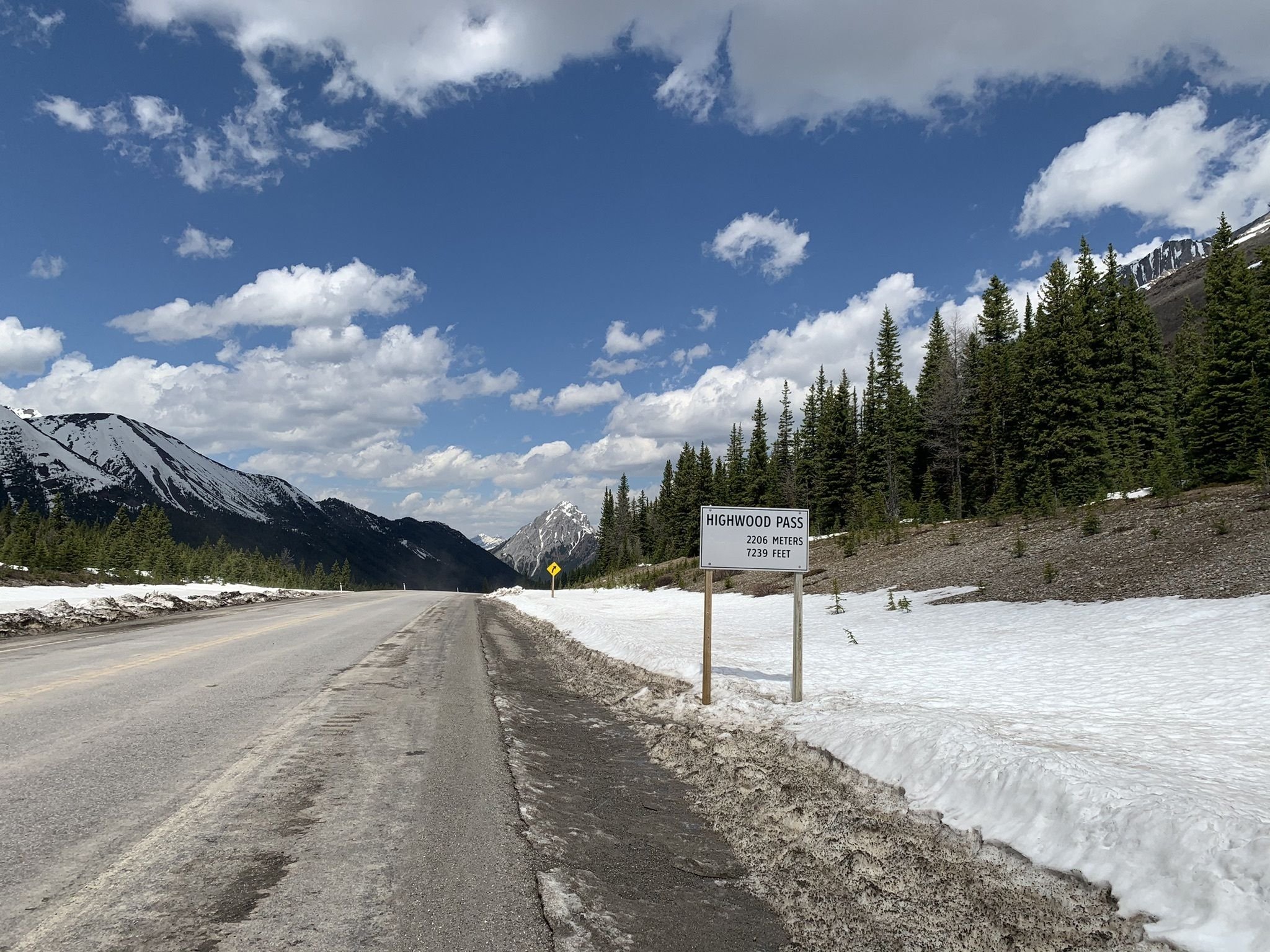
This is an out and back ride, as the road will loop back on itself at the top of the climb, so it is a very straight forward in terms of navigation. So you really have two options, start at the winter gate, or for a longer ride start in Diamond Valley (Tuner Valley). Turner Valley and Black Diamond into Diamond Valley in 2022, maps at this time still show the town as it’s older names, and even at the time of writing this, much of the road signage still refers to the old town names, so just be aware at some pint there may be changes on things such as google maps.

Ultimately this route travels along Highway 546, with 18 kilometers (36 kilometers return) of the road closed until May 15th. For a little more of a challenge leaving from Diamond Valley (Turner Valley) the route is a total of 77.86 kilometers, with a total of 825 meters of elevation. Public parking is available near the Diamond Valley Public Campground, as well as the Sheep River Library. Just be aware that when the pool opens for the summer, you may have to find street parking.

Elevation Map Diamond Valley (Tuner Valley) to Sheep River Summit

Getting onto the route is as simple as heading down main street and turning west on to Sunset Boulevard when you hit the big four way stop. Then it is simply follow the road, and as you leave town it turns into Highway 546.

It is also important to note that especially when the road is closed, that there can be a fair amount of wild life from goats to bears. Just be aware, and keep a respectful distance for any wild life. Just know on the descent that it isn’t uncommon for a pack of sheep to congregate on the road, so be aware on your descents. Bears are also frequent enough that groups will also pack some bear spray just in case.

Finally even after the gates open you can do this route, but just be known that the shoulder has seen better days in sections of this climb, and I for one would want to avoid descending in the shoulder. Ultimately nothing beats a great day of riding in the mountains. You can download the GPS data over on Kamoot, and if you do this ride please do share your experience, photos and video links in the comments below!

Highwood Pass - Cycling the Highest Paved Road in Canada

Photo: Kevin Lenz

Without a doubt, Alberta is home to some of the most beautiful mountain scenery in the world. On such place is Highwood Pass, which also hold the title of Canada’s highest paved road with a summit at 2206 meter or 7239 feet. It is an amazing piece of highway that slices through Kananaskis Country. For cyclists the beauty of this ride is that prior to June 15th the road is closed to vehicular traffic. This gives you the opportunity to fully enjoy riding this, and the serenity of nature that this area has to offer.

Please be aware that if you plan on doing this ride prior to June 15th, that the weather is unpredictable, so prepare accordingly. It is not uncommon that riding this route in May, you will be greeted by snow the closer you get to the summit, sometime making it only possible to make it to the top by hiking the last few kilometers. Being Alberta, you can also get snow even after the road opens. Also note that in areas of this ride, you are likely to be out of cell phone coverage.

In this post we are going to focus on the South Climb, which has a greater elevation gain, but a lower average gradient. The South climb is an out and a back ride. Depending on where you park in comparison to the south gate will determine you ride, but overall you are looking at approximately 76km and a total of 1816m of elevation gain on your ride. May to June is the best time to get out and enjoy the climb, and if you search Facebook, often riders will share how close they get to the summit before they hit snow for earlier dates. Also note that the final weekend before the road opens is traditionally a very busy weekend to ride this route, but often adds to the atmosphere as there is always a large crowd of people at the summit reveling on their day’s accomplishment.

Elevation Map Highwood Pass

So make sure to bring enough water and food for your adventure, as there is nowhere on route to fuel up,. It is also important to note that you will notice a noticeable change in temperature between the base and summit. Even though you may not need a jacket or gilet for the climb, you are likely going to want to pack one. When we road this route it began snowing at the summit upon our arrival, and during the descent you notice the temperature quickly, just due to the fact that you are not working as hard.

It is also important to note that especially when the road is closed, that there can be a fair amount of wild life from goats to grizzly bears. Just be aware, and keep a respectful distance for any wild life. Just know on the descent that it isn’t uncommon for a pack of sheep to congregate on the road, so be aware on your descents. Bears are also frequent enough that groups will also pack some bear spray just in case.

Finally even after the gates open you can do this route, but just be known that the shoulder has seen better days in sections of this climb, and I for one would want to avoid descending in the shoulder. Ultimately nothing beats a great day of riding in the mountains. You can download the GPS data over on Kamoot, and if you do this ride please do share your experience, photos and video links in the comments below!

Leave a TIP TO help us create content

Cycling to Moraine Lake and Lake Louise!

Photo by Bantersnaps

Photo by Bantersnaps

In Banff National Park, Moraine Lake is a glacial-fed lake 14kms outside the village of Lake Louise. Without a doubt, it is one of the most beautiful places in the world. The lake is famous for its azure blue waters and being surrounded by snowcapped peaks in the area known as the Valley of Ten Peaks. This combined makes it one of the most picturesque locations sought by tourists the world-around, as it creates the definitive Canadian mountain backdrop. To be frank it is a breathtaking view.

Moraine Lake is a Cat. 2 climb that is accessible from May to September. For cyclists, the beauty here is if you time things right you will be able to do this climb, before the parks opens the road to vehicular traffic. Just before the May Long weekend, the park will clear the final bit of snow from the roadway, giving cyclists the perfect opportunity to ride up traffic free!

Elevation Map of Moraine Lake Climb

Elevation Map of Moraine Lake Climb

Even with the increased popularity of the area over the past few years, after the road opens for the season traffic is not as bad as one might think. This is because cars are restricted once the parking is full in the morning, making still an enjoyable ride with limited cars. Even so, depending on where you want to start your ride during the summer, parking in the Lake Louise area can be limited, so plan to arrive early if you strictly want to do the climb.

If you start at the base of Moraine Lake road, you are looking at a climb of 8.5 km’s with an average gradient of 4 percent. To the lake, it is 11.4 km’s, as you will have a small 55-meter descent from the peak elevation of 1738 meters. The out and back is recommend for someone with moderate fitness, or if you want a little adventure I imagine a beginner would have a fantastic time on an e-bike. The ride will be approximately an hour to the lake and half hour return, depending on fitness and bike skills for the descent.

For an added challenge, and a little more climbing one can start from the Lake Louise Visitor Centre. This will add an additional 121 meters of climbing over 1.63 km’s with an average gradient of 7.4% and a maximum gradient of 13% before turning left on Moraine Lake Road to complete the rest of the trip as described above.

If you start at the visitor center, a café stop may be in order. We recommend that you grab a slice of pizza or a brownie if you have a sweet tooth from Laggan’s Mountain Bakery & Delicatessen, along with a nice cup of espresso to round out the day. The Village Market that is directly next door is also a fantastic place to grab fluids and snacks, especially if this ride was part of a longer out and back ride along the Bow Valley Parkway from Castle Junction or Banff.

If you are visiting the area, and are likely not to return anytime soon for another ride, or have never visited the area, once completing the climb to Moraine Lake, rather than turning right to descend on Lake Louise Drive, consider turning left, and visiting Lake Louise and the Fairmount Chateau, which is another world renowned view. It is just an additional 2.3 km’s and 89 meters of climb, before your reach the Chateau Lake Louise, and provides another fantastic opportunity to refuel with an amazing view. Just keep in mind that the road to the Chateau is a little busier in terms of traffic, but again does quiet down once the lots are full, and traffic are diverted to the Lake Louise overflow parking.

Now if you do happen to arrive late, and are unable to park at Lake Louise, rather than starting from the Lake Louise overflow parking. I recommend starting your ride from Castle Junction, and ride to Lake Louise via the Bow Valley Parkway. This route covers 83.1 km’s and includes 990m of total climbing.

You can get the route for Castle Mountain to Moraine Lake - Out and Back on Kamoot by clicking the link: https://www.komoot.com/tour/379008509?ref=wta

Photo by: Jakub Fryš

Photo by: Jakub Fryš

With the gorgeous scenery, the opportunity to ride traffic free, we think that this really is a bucket list climb. An absolute must for anyone visiting the Rocky Mountains!